Thursday 9 October 2014

The Night Stair


Original photo from 1990 dig showing spiral stair
© Albion Archaeology, reproduced with permission
In 1990, workmen digging new drains on the south side of St Peter's church in Harrold uncovered the remains of a medieval spiral staircase.  There are no obvious clues as to what these stairs were for, but the assumption was made that they were something to do with the former Harrold Priory, which was known to be sited to the south of the church.


The remains form part of the foundations of the south east corner of the south aisle.  This aisle, it is clear from the records, archaeology and walls, was shortened at some stage in the late middle ages or early Tudor period.  Even before this shortening, a large doorway had been cut into this wall immediately above the remains of the staircase: this doorway was later blocked again on the outside, but is still clearly visible from within the church, where it can be seen behind the organ.

The 1990 work was overseen by Albion Archaeology from Bedford, and no further traces of Harrold Priory were found.  However, based on existing remains and archaeological work on other nunneries in England it is possible to speculate that the steps found at Harrold were the remains of the nuns' 'night stair'.   An example of one of these is described by Roberta Gilchrist and Marilyn Oliva at Carrow Priory in Norfolk.  This had a layout typical of medieval nunneries, with a row of monastic buildings joining the church at the south aisle - at the same point that the Harrold stair was discovered.  Carrow's stairs were in a 'slype' at the south transept, and led down from the nuns' dormitory.  They were used to allow the nuns access to their chapel for the night services (matins at 2 am daily).

Carrow's layout, with night and day rooms plus chapter house to the south of the church, and with cloisters attached to the west of these, was common enough both in women's houses and in men's.  Carrow had many similarities to Harrold Priory, having been founded in the same period, having been on the edge of a village, and having accommodated a maximum of a dozen nuns.  Carrow, like Harrold, was never well endowed and struggled on small benefactions and rents from landholdings.


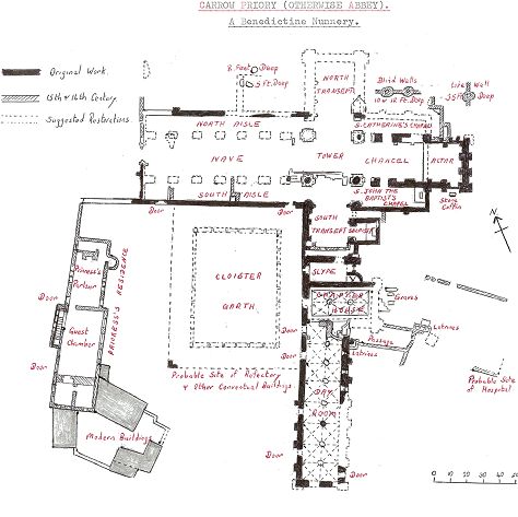
Plan of Carrow Priory in Norfolk (source: georgeplunkett.co.uk)
The night stair idea at Harrold does not fit the evidence readily, though.  Why was it removed and built over?  When the door was cut into the south aisle, how did the nuns gain access from the dortor at night?   One possible explanation is that the remains discovered in 1990 were from very early in the Priory's life, and were in something like Carrow's slype, attached to the main aisle or nave of St Peter's.  When, in the 14th century, a new south aisle was constructed, the nun's access to the church was rebuilt further south.  In this scenario the new night stairs would be in a lobby or slype, which would then give access to the south aisle via a new doorway.

It is also possible that there was more than one chapel to the south, as can be seen at Carrow.  Perhaps the nuns had a private chapel to the south of the chancel (where there are no windows), while there was a new general 'public' aisle to the south of the nave.  This again was a common medieval arrangement where the nuns shared their space of worship with the townsfolk. We do know from the Harrold Cartulary (a collection of legal documents, now in the British Museum), that the nuns' chapel was distinct from the main church, as the bishop of Lincoln had to remind the Prioress of her duty to supply bread and wine for both the main church and the nuns' private chapel (Document 207 cited in Fowler 1935).

A conjectural plan of Harrold Priory, taking the Carrow model, would have accommodation extending south from the main church, and forming the east side of the cloister.  The west side would be service accommodation - kitchens (possibly with running water in an artificial stream beneath), brewery, dairy, stores, etc.  The north side of the cloister would adjoin the church's south aisle while the south side of the cloister would be enclosed.  But whereas the nuns of Carrow built a new guest wing and infirmary to the west of the cloister in the late middle ages, at Harrold - we can speculate - a new 'modern' building of this kind went up to the east of the cloister.  This was a more serviceable and comfortable building, with the Prioress's private lodgings as well as rooms with fireplaces for corrodians (people who had paid to be cared for in their old age).  If the Norfolk pattern from Carrow was repeated in Bedfordshire, at the time of the dissolution this new wing was then remodeled into what then became known as Harrold Hall.


References

For more photographs of the Nuns' Stream and other remains, please visit my Harrold Priory collection on Flickr.


Wednesday 8 October 2014

The Nuns' Stream


Remains of what may have been the walls of the Priory grounds
In 1268 Prioress Amice obtained the permission of Ralf Morin IV (Lord of the Manor of Harrold) to divert a brook.   As part of this agreement the Prioress undertook not to use the brook to drive a mill. The records do not specify where the stream was, but there is only one brook anywhere near to the site, the one running down what is now called Church Walk and then into the Great Ouse river.  This stream seems to have formed the western boundary of the Priory, and there are what appear to be the remains of substantial stone walls still standing here at what was probably the north west corner of the Priory precincts.

In their authoritative study of nunneries in East Anglia, Roberta Gilchrist and Marilyn Oliva found no evidence of diverted streams: indeed they point out that while the practice was common in men-only monasteries, "female houses seldom possessed such elaborate facilities".  Water was diverted to provide fresh water for the kitchens and channels to flush the monastic latrines. Eileen Power described how Abbess Euphemia had ordered a stream to be diverted for this purpose at Wherwell Abbey in the 13th century.  The agreement between Prioress Amice and Ralph Morin tells us that the new water course was not used for milling, but has no further details as to its purpose.

In September 2014 some local residents and I made a close inspection of the stream.  We had previously found a reference on the 1902 Ordnance Survey map to "sluices" part the way down the stream, as well as two footbridges.  We found no clear evidence of either, although there were some remains of a concrete structure on the bed of what we were now calling the Nuns' Stream.  However, we did find that downstream from the Wellocks bridge by Church Walk for about 100 metres, the stream had been carefully and substantially culverted between stone walls.  These were about 2 metres in height and extended the length of the stream to about 30 metres beyond the point where we suppose the sluices were installed (the stream takes a sharp right hand turn at this point).

What appears to be an arched entrance to a new underground
stream feeding the Priory with fresh water
The walls to the culvert are heavily overgrown now, and in places have been undermined by
flooding, but are still clearly visible.  As they follow the stream down from Wellocks, the space widens from about two metres to around five at its widest point.  This, with the stream being dammed by sluices lower down, would have created a very substantial artificial pond with a large head of water.  About a metre down from the top of the culverting, immediately before where we imagine the sluices were, there appear to be the remains of an arched opening to an underground channel to take water to the Priory.

This evidence, though, is inconclusive as the stream is heavily silted up at this point.  There is no evidence of the Priory stream today and it is likely to have been built over by later development in the 19th and 20th century.  However, on the opposite side of the former Priory site, along the banks of the Great Ouse, there are the remains of what appears to be a substantial stream or drain originating in the the remains of the Priory or Hall.  The outflow here is said to be arched and built of stone, similar to what we observed at the Nuns' Stream side of the site.  The remains are close to a Victorian boathouse, but have been buried in recent landscaping work by one of the local residents. This outflow is also visible on 19th century ordnance survey maps.

The new pond: stone lined, two metres deep and 5 metres wide
at this point.  A substantial body of water to feed the Priory.
It is possible that these works were done by one or other of the tenants at Harrold Hall, rather than the nuns at the Priory.  However, the stonework appears to be well weathered and consistent with other late medieval stonework nearby, such as the walls of St Peter's church.  My guess is that the nuns had the stream culverted in the 13th century, with an underground stream running to the western side of their cloister where perhaps there were kitchens or latrines.  The stream then carried on out and discharged into the Great Ouse. The flow of water into this culvert was controlled by means of sluices which kept a large head of water in the artificial pond on the edge of the site, and backing up Church Walk towards the High Street.


References
For more photographs of the Nuns' Stream and other remains, please visit my Harrold Priory collection on Flickr.